
Swim-Run Virginia
Events
| SwimRunVA : Off Road |
| Adventure Race : 18.32 miles swim and run |
- Race Date: Saturday, October 21, 2017
- Start Time: 7:00am
- Entry Fee:$490 per team of 2-early registration discounts
- Location:3 Sports Richmond, VA for starting line
- Address: 6241 River Rd, Richmond, VA 23229
- City/State/Zip:Richmond, Virginia 23234
- Country: USA
- Registration Website: https://www.raceit.com/Registe...
- Race Website http://www.swimrunva.com
- Telephone: 804-271-8271
- Email: [email protected]
SwimRunVA starts with serene views of the sunrise over the James River mixed with beautiful trails starting at Huguenot Flatwater Park.
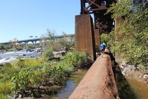
After this long swim to the Z dam, it’s time for quick but technical swim around some rapids. The course then takes you on a run at Pony Pastor and into the quick moving part of the river for a fast 1000 meter swim. Moving into more urban features of the event, racers will run through quiet neighborhoods and over Richmond’s downtown expressway into a short sprint swim under the Boulevard bridge. Next is a 2.87 mile run from Texas beach trail to Northbank trail to Belle Isle which is arguably the funnest and most challenging leg of the race. After a quick swim and breathtaking city skyline views from Richmond’s Floodwall, your final swim finishes at Chappel Island and Great Shiplock park. The home stretch is a 2 mile run that includes the Richmond terminus of the Capital Trail, Shockoe Bottom, and the Canal Walk across the pipeline trail into Brown’s Island. A final sprint for the finish to the River bank across from the Tredegar American Civil War museum will complete you amazing journey.
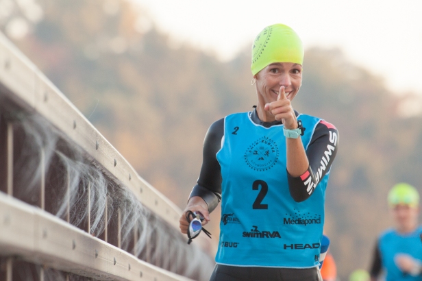
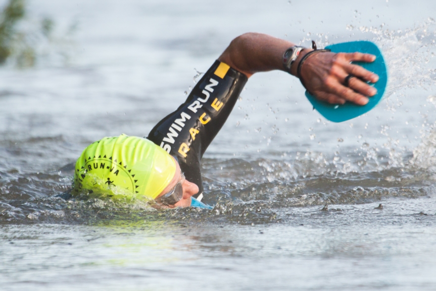
Swimrun is about camaraderie. It is about emotion. It challenges you to work together with a partner while overcoming your own physical and mental barriers. Swimrun is a new concept that is catching on quickly in the states. Richmond hit yet another home-run with this event and SwimRunVA is so unique because of its one-of-a-kind course mixed with beautiful trails and urban views. If you have ever really wanted to feel like you are part of Richmond, SwimRunVA is the perfect event. Registration for the 2017 SwimRunVA event on October 21, 2017 is now live. Do you have what it takes?
Course Information:
Leg 1 - 3Sports Start - Run 2.14 KM/1.33 MI
To start your 2017 SwimRunVA Richmond Race, you will take a shuttle from the headquarters hotel in downtown RVA to the parking lot of 3Sports, our starting line sponsor for the 2017 Race. After leaving 3Sports, the race will take you across the Huguenot bridge. As the Sun rises to the east, enjoy the race's first view of Virginia's historic James River. But stay focused! There's a long way to go.
3sports: http://www.threesports.com/
Leg 2 - Flatwater - Swim 1.8 KM/1.12 MI
From here, almost all of the next 16 miles will be spent inside the unique, urban James River Park System. The start of your first swim is at the kayak launch of Hueguenot Flatwater Park. Your first swim will also be your longest as you travel the flatwater towards Williams Island, a nature preserve.
Huguenot Flatwater Park: https://www.visitrichmondva.com/listings/huguenot-flatwater-park/1252/
Leg 3 - Williams Island Shoreline - Run 0.17 KM/0.0999 MI
You'll exit your swim just before the Z dam, a popular proving ground for freestyle paddlers. This leg will take you around the dam and along the southern coast of Williams Island, the Park System's nature preserve, for a short run to a beach entry.
Williams Island: https://www.visitrichmondva.com/listings/williams-island/3314/
Leg 4 - Run the Rapids - Swim 0.25 KM/0.16 MI
Time to kick it into high gear! This short 250 meter swim will require you to plan your line with the help of the course marshalls and kayak support. You will challenge yourself through a set of light rapids to the southern shore and Riverside Meadows.
Leg 5 - Meadows to Pasture - Run 1.32 KM/0.82 MI
From the Meadows you have a flat-ground sprint into Pony Pasture Park along Riverside Drive. If you can afford to take your focus off the race, you might take a second to listen to the River and enjoy the views of one of Richmond's most picturesque drives.
Pony Pasture: https://www.visitrichmondva.com/listings/pony-pasture-rapids/3303/
Leg 6 - Pony Pasture Buoy Round - Swim 1.05 KM/0.65 MI
After your sprint into Pony Pasture you will launch into a flatwater swim. This 1000 meter swim will round a set of buoys in the northern channel. This will be a fast swim as you move with the current in the flattest section of the course.
Leg 7 - Over the Hump - Run 7.77 KM/4.83 MI
Over the hump is so named because it is the longest run of the race. Your surroundings will change as you make your way through the first real urban leg of the course, crossing through quiet neighborhoods as well as over one of Richmond's crosstown expressways. The run drops back into the park on the western tip of Buttermilk trail, a challenging single track with numerous hill climbs.
Buttermilk: http://rvamore.org/trails/jrps/buttermilk/
Leg 8 - Under the Bridge - Swim 0.33 KM/0.21 MI
Under the Bridge is a short sprint swim that passes directly under the Boulevard Bridge. The last 20 meters will be a true test of competitors' strategic thinking as they traverse the river rocks which guard the northern shore.
Texas Beach and Northbank Trail: http://www.richmondoutside.com/destination/northbank-trail-and-texas-beach-jrps/ Belle Isle: https://www.visitrichmondva.com/listings/belle-isle/1255/
Leg 9 - Texas North Belle - Run 4.63 KM/2.87 MI
Texas Beach trail to Northbank trail to Belle Isle. This leg is arguably the funnest and most challenging segment you'll race through. Texas Beach is a flat, fast run with exquisite scenery. You know you have entered Northbank trail when you cross the train tracks and enter the most technical trail of the course. This leg ends with a trip across the suspension bridge to Belle Isle, a Union soldier prison camp from the Civil War. Upriver, you'll see the splendor of the James and the wildlife it supports, while the downriver view is of a sprawling, thriving Richmond downtown built right up to the river banks. This is where you will want to snap your mental cameras-- these views will stay with you for a lifetime.
Suspenion Bridge: http://www.rvariverfront.com/trails/belleisle.html
Leg 10 - Round the Rock - Swim 0.76 KM/0.47 MI
The fifth swim of the race is a half mile leg around a small island overlooked by the finish area. Spectators will be able to watch this section of the race from many different vantage points. One of the most popular will be the new Tyler Potterfield Dam Walk which is schedule to be done August 2016.
https://rvanews.com/news/browns-island-dam-walk/108501
Leg 11 - Run the Floodwall - Run 4.58 KM/2.81 MI
You'll exit the swim back on Belle Isle, and will run the Outer Rim to Buttermilk East. From there you will circle some of Richmond's urban ruins and enter the floodwall run. This is a super fast section of the course, on top of Richmond's Floodwall on the southern shore of the James. The city skyline will dominate the views as you try to outrun the James as you finish on part of the Richmond Slave Trail in Shockoe Bottom.
Floodwall Park: https://www.visitrichmondva.com/listings/floodwall-park/3301/
Richmond Slave Trail: http://www.virginia.org/listings/historicsites/richmondslavetrail/
Leg 12 - Chappel Island - Swim 1.23 KM/0.76 MI
The final swim of the course is the second longest. From the 14th street take out, you will pass by Mayo island heading downriver into the tidal section of the lower James. Depending on the tide, this could be a very fast swim or a challenging push. The finish is Chappel Island and Great Shiplock Park. The island is known as the site of Trigg Shipyard. In the early 20th century Trigg constructed tugboats, small destroyers and some of first oil tankers on the island, which is separated from the northern bank by the Kanawha Canal.
14 Street Takeout: https://www.visitrichmondva.com/listings/14th-street-takeout/3305/
Mayo's Island: http://www.richmondgov.com/planninganddevelopmentreview/documents/PlansRiverfront/8_Mayos_Island.pdf
Chappel Island: http://www.hmdb.org/marker.asp?MarkerID=47430
Great Shiplock Park: https://www.visitrichmondva.com/listings/great-shiplock-park/3307/
Leg 13 - Pipeline to Civil War Finish - Run 3.52 KM/2.19 MI
From Chappel Island, you'll cross over the start of the Kanawha Canal- a manmade waterway surveyed and planned by George Washington to connect western Virginia with the James River and the Virginia seaport. Once over the Canal, the home stretch includes the Richmond terminus of the Capital Trail, Shockoe Bottom, and the Canal Walk across the pipeline trail to Brown's Island. From Brown's Island, you will sprint to the finish on the River bank across from the Tredegar American Civil War museum.
Previous Results:
http://www.swimrunva.com/results/
SwimRunVA starts with serene views of the sunrise over the James River mixed with beautiful trails starting at Huguenot Flatwater Park.
After this long swim to the Z dam, it’s time for quick but technical swim around some rapids. The course then takes you on a run at Pony Pastor and into the quick moving part of the river for a fast 1000 meter swim. Moving into more urban features of the event, racers will run through quiet neighborhoods and over Richmond’s downtown expressway into a short sprint swim under the Boulevard bridge. Next is a 2.87 mile run from Texas beach trail to Northbank trail to Belle Isle which is arguably the funnest and most challenging leg of the race. After a quick swim and breathtaking city skyline views from Richmond’s Floodwall, your final swim finishes at Chappel Island and Great Shiplock park. The home stretch is a 2 mile run that includes the Richmond terminus of the Capital Trail, Shockoe Bottom, and the Canal Walk across the pipeline trail into Brown’s Island. A final sprint for the finish to the River bank across from the Tredegar American Civil War museum will complete you amazing journey.
Swimrun is about camaraderie. It is about emotion. It challenges you to work together with a partner while overcoming your own physical and mental barriers. Swimrun is a new concept that is catching on quickly in the states. Richmond hit yet another home-run with this event and SwimRunVA is so unique because of its one-of-a-kind course mixed with beautiful trails and urban views. If you have ever really wanted to feel like you are part of Richmond, SwimRunVA is the perfect event. Registration for the 2017 SwimRunVA event on October 21, 2017 is now live. Do you have what it takes?
Course Information:
Leg 1 - 3Sports Start - Run 2.14 KM/1.33 MI
To start your 2017 SwimRunVA Richmond Race, you will take a shuttle from the headquarters hotel in downtown RVA to the parking lot of 3Sports, our starting line sponsor for the 2017 Race. After leaving 3Sports, the race will take you across the Huguenot bridge. As the Sun rises to the east, enjoy the race's first view of Virginia's historic James River. But stay focused! There's a long way to go.3sports: http://www.threesports.com/
Leg 2 - Flatwater - Swim 1.8 KM/1.12 MI
From here, almost all of the next 16 miles will be spent inside the unique, urban James River Park System. The start of your first swim is at the kayak launch of Hueguenot Flatwater Park. Your first swim will also be your longest as you travel the flatwater towards Williams Island, a nature preserve.Huguenot Flatwater Park: https://www.visitrichmondva.com/listings/huguenot-flatwater-park/1252/
Leg 3 - Williams Island Shoreline - Run 0.17 KM/0.0999 MI
You'll exit your swim just before the Z dam, a popular proving ground for freestyle paddlers. This leg will take you around the dam and along the southern coast of Williams Island, the Park System's nature preserve, for a short run to a beach entry.Williams Island: https://www.visitrichmondva.com/listings/williams-island/3314/
Leg 4 - Run the Rapids - Swim 0.25 KM/0.16 MI
Time to kick it into high gear! This short 250 meter swim will require you to plan your line with the help of the course marshalls and kayak support. You will challenge yourself through a set of light rapids to the southern shore and Riverside Meadows.
Leg 5 - Meadows to Pasture - Run 1.32 KM/0.82 MI
From the Meadows you have a flat-ground sprint into Pony Pasture Park along Riverside Drive. If you can afford to take your focus off the race, you might take a second to listen to the River and enjoy the views of one of Richmond's most picturesque drives.Pony Pasture: https://www.visitrichmondva.com/listings/pony-pasture-rapids/3303/
Leg 6 - Pony Pasture Buoy Round - Swim 1.05 KM/0.65 MI
After your sprint into Pony Pasture you will launch into a flatwater swim. This 1000 meter swim will round a set of buoys in the northern channel. This will be a fast swim as you move with the current in the flattest section of the course.
Leg 7 - Over the Hump - Run 7.77 KM/4.83 MI
Over the hump is so named because it is the longest run of the race. Your surroundings will change as you make your way through the first real urban leg of the course, crossing through quiet neighborhoods as well as over one of Richmond's crosstown expressways. The run drops back into the park on the western tip of Buttermilk trail, a challenging single track with numerous hill climbs.Buttermilk: http://rvamore.org/trails/jrps/buttermilk/
Leg 8 - Under the Bridge - Swim 0.33 KM/0.21 MI
Under the Bridge is a short sprint swim that passes directly under the Boulevard Bridge. The last 20 meters will be a true test of competitors' strategic thinking as they traverse the river rocks which guard the northern shore.Texas Beach and Northbank Trail: http://www.richmondoutside.com/destination/northbank-trail-and-texas-beach-jrps/ Belle Isle: https://www.visitrichmondva.com/listings/belle-isle/1255/
Leg 9 - Texas North Belle - Run 4.63 KM/2.87 MI
Texas Beach trail to Northbank trail to Belle Isle. This leg is arguably the funnest and most challenging segment you'll race through. Texas Beach is a flat, fast run with exquisite scenery. You know you have entered Northbank trail when you cross the train tracks and enter the most technical trail of the course. This leg ends with a trip across the suspension bridge to Belle Isle, a Union soldier prison camp from the Civil War. Upriver, you'll see the splendor of the James and the wildlife it supports, while the downriver view is of a sprawling, thriving Richmond downtown built right up to the river banks. This is where you will want to snap your mental cameras-- these views will stay with you for a lifetime.Suspenion Bridge: http://www.rvariverfront.com/trails/belleisle.html
Leg 10 - Round the Rock - Swim 0.76 KM/0.47 MI
The fifth swim of the race is a half mile leg around a small island overlooked by the finish area. Spectators will be able to watch this section of the race from many different vantage points. One of the most popular will be the new Tyler Potterfield Dam Walk which is schedule to be done August 2016.https://rvanews.com/news/browns-island-dam-walk/108501
Leg 11 - Run the Floodwall - Run 4.58 KM/2.81 MI
You'll exit the swim back on Belle Isle, and will run the Outer Rim to Buttermilk East. From there you will circle some of Richmond's urban ruins and enter the floodwall run. This is a super fast section of the course, on top of Richmond's Floodwall on the southern shore of the James. The city skyline will dominate the views as you try to outrun the James as you finish on part of the Richmond Slave Trail in Shockoe Bottom.Floodwall Park: https://www.visitrichmondva.com/listings/floodwall-park/3301/
Richmond Slave Trail: http://www.virginia.org/listings/historicsites/richmondslavetrail/
Leg 12 - Chappel Island - Swim 1.23 KM/0.76 MI
The final swim of the course is the second longest. From the 14th street take out, you will pass by Mayo island heading downriver into the tidal section of the lower James. Depending on the tide, this could be a very fast swim or a challenging push. The finish is Chappel Island and Great Shiplock Park. The island is known as the site of Trigg Shipyard. In the early 20th century Trigg constructed tugboats, small destroyers and some of first oil tankers on the island, which is separated from the northern bank by the Kanawha Canal.14 Street Takeout: https://www.visitrichmondva.com/listings/14th-street-takeout/3305/
Mayo's Island: http://www.richmondgov.com/planninganddevelopmentreview/documents/PlansRiverfront/8_Mayos_Island.pdf
Chappel Island: http://www.hmdb.org/marker.asp?MarkerID=47430
Great Shiplock Park: https://www.visitrichmondva.com/listings/great-shiplock-park/3307/
Leg 13 - Pipeline to Civil War Finish - Run 3.52 KM/2.19 MI
From Chappel Island, you'll cross over the start of the Kanawha Canal- a manmade waterway surveyed and planned by George Washington to connect western Virginia with the James River and the Virginia seaport. Once over the Canal, the home stretch includes the Richmond terminus of the Capital Trail, Shockoe Bottom, and the Canal Walk across the pipeline trail to Brown's Island. From Brown's Island, you will sprint to the finish on the River bank across from the Tredegar American Civil War museum.
Previous Results:
http://www.swimrunva.com/results/
Race Reviews
Race Photos
No photos entered yet.
Add Your Event Photo